Spokane Valley Cycling

Tuesday, January 27, 2015

Advantages and Disadvantages of Map Projections

Different map projections can have certain benefits and disadvantages. Three types of map projections were represented in the current assignment – equal area, equidistant and conformal. As the name suggests, equal area maps preserve areas of features. To preserve areas, “other properties—shape, angle, and scale—are distorted” (arcgis.com). Equidistant maps preserve the distances between different points. The drawback of equidistant maps is that scale cannot be preserved throughout the entire map. Lastly, conformal map projections are designed to preserve a local shape. As described on arcgis.com, “To preserve individual angles describing the spatial relationships, a conformal projection must show the perpendicular graticule lines intersecting at 90-degree angles on the map. A map projection accomplishes this by maintaining all angles. The drawback is that the area enclosed by a series of arcs may be greatly distorted in the process.”
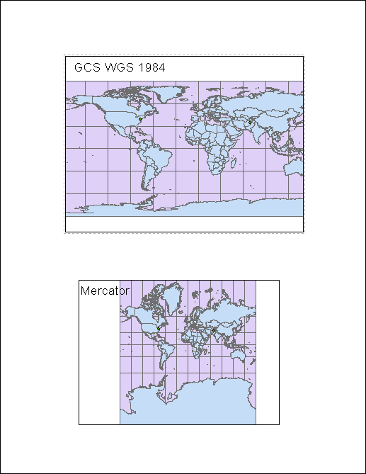
Experimenting with various map projections in ArcMap made the benefits and disadvantages of map projections readily apparent. To project a three dimensional object – namely Earth – onto a two dimensional medium certain distortions must take place. Different projections are designed to mitigate particular distortions. Yet, the mitigation of a particular distortion results in the exacerbation of another distortion. For example, the Mercator projection is designed for little distortion of shape near the equator. To provide the lower distortions near the equator, greater distortions are evident near the poles. This can be recognized on a Mercator projection of the globe. Antarctica appears to be much larger than it is in actuality.
The distortions that arise with map projection are inevitable. As previously noted certain distortions can be exacerbated in map projections. Conversely, certain distortions are lessened for a variety of purposes. For instance the equidistant conic projection defines two standard parallels that feature no distortion. If areas along these parallels were of interest, this type of map projection would be suitable. This is just one example of the mitigation of distortions. The complete description of distortions is not the intent of this paper.
Evidently, no one map can be described as the greatest overall. Certain projections work best for certain situations. The numerous types of map projections each represent a set of distortions – some of which are great and others that are lessened. The six projections illustrate in the previous example provide additional insight into map distortions. The six projections provided early are: GCS WGS 1984, Mercator, Equidistant Conical, Equidistant Cylindrical, Berhmann, and Cylindrical Equal Area.


Works Cited
"ArcGIS Help 10.1." ArcGIS Help 10.1. N.p., n.d. Web. 27 Jan. 2015.

Map Projections


This post features six different map projections that illustrate variability in map projections.


GCS WGS 1984
Distance between Washington, DC and Kabul, Afghanistan
·         Geodesic – 100.36 Decimal Degrees
·         Loxodrome – 117.4 Decimal Degrees
·         Great Elliptic – 100.4 Decimal Degrees
The Geodesic and Great Elliptic measurements feature lines with an arc, while the loxodrome measurement features a straight line.

Mercator
Distance between Washington, DC and Kabul, Afghanistan
·         Geodesic – 11,159,983 meters
·         Loxodrome – 13,055,122 meters
·         Great Elliptic – 11,159,992 meters

Equidistant Conic
Distance between Washington, DC and Kabul, Afghanistan
·         Geodesic – 11,159,983 meters
·         Loxodrome – 13,055,122 meters
·         Great Elliptic – 11,159,992 meters

Equidistant Cylindrical
Distance between Washington, DC and Kabul, Afghanistan
·         Geodesic - 11,159,983 meters
·         Loxodrome – 13,055,122 meters
·         Great Elliptic – 11,159,992 meters

Behrmann
Distance between Washington, DC and Kabul, Afghanistan
·         Geodesic - 11,159,983 meters
·         Loxodrome – 13,055,122 meters
·         Great Elliptic –  11,159,992 meters

 Cylindrical Equal Area
Distance between Washington, DC and Kabul, Afghanistan
·         Geodesic – 11,159,983 meters
·         Loxodrome – 13,055,122 meters
·         Great Elliptic – 11,159,992 meters


Monday, January 26, 2015

My Initial ArcMap Experience

          My initial experience with Arc Map was in a word, frustrating. The program’s user interface was somewhat unintuitive. Seemingly, it takes substantial practice with the program to become a proficient user. The layout of the program is sensible, but various commands and features of the program are unintelligible and can be disconcerting when trying to use. For example, the Select tool in the ArcMap program seems to only select items under certain conditions. Although I may have been making a mistake in the use of the tool, one would assume that the point and click technique would be all that was required.

          Additionally, another frustrating aspect of ArcMap was the addition of text onto a layout. Editing text in a text box cannot be done with a simple click in the text box to produce a cursor, as is common in various software programs. To edit certain text boxes in ArcMap, a user needs to double click on a box or right click to edit it. Another part of ArcMap I found bothersome was the lag of the program. Every time I use the program, the software lags regardless of the computer. Surely, others have voiced similar concerns and dislikes about the ArcMap program.

         Despite my negative opinions of ArcMap, I recognize that this program is a very useful and powerful geographic tool. This short tutorial over ArcMap elucidated several applications for GIS and the benefits that GIS provides. For instance, the use of GIS to plot population densities as well as various physical features would be very useful in land management or city planning. Also, GIS would be useful in the construction industry. ArcMap and other similar programs could be used to display the geographic extent of a construction site. Of course, these are just a couple of the numerous applications of ArcMap. By the use of a skilled professional, ArcMap has the potential to be a powerful geographic tool.

         Certain negative aspects may arise from the use of ArcMap. If the user does not have adequate training, a substandard work may be produced. Although substandard can have an array of meanings in this context, some may be more serious than others. For instance, incorrect font size or text placement will hardly cause any affairs. Yet, the incorrect placement of parcel lines has the potential to result in serious negative consequences. Surely, the positive consequences of GIS outweigh the negative consequences of GIS.


Proposed Airport Expansion - Lab III


Wednesday, January 14, 2015

Negative Aspects of Neogeography


Current accessibility of geographic tools has provided individuals with easy access to create personal maps and geographic works. Although increased access of information and technology is usually viewed as progress, certain negative consequences may arise from availability of geographic technology. As a result of accessibility, nearly anyone can create geographic products - which in turn, allows for people with little geographic experience to produce works. These neogeographers may lack the proper training to produce credible or reliable works and create a false representation of the world. Individuals interpreting these maps may then be misled and presented with false information. Furthermore, without proper training neogeographers may produce non-standard works which may also result in confusion among users. Production of inadequate works may result in lower regard or inability to recognize credible works.

Neogeographers may also produce works that are influenced by opinion. Consequently, a correct or factual model of spatial data may be skewed. Additionally, privacy may be infringed upon with the high accessibility of mapping tools. For instance, Google Maps provides nearly complete satellite imagery of Earth’s surface. Thus, a map may be created using satellite imagery of private property which may violate privacy laws. The lack of experience of neogeographers may be the only limiting factor in the production of credible maps. Neogeographers are likely using inadequate technology to produce high quality works. Seemingly, increased availability of information technology is beneficial. However, with the increased availability, recognition of certain negative consequences must be present.


The Case of the Snail Darter


The Snail Darter versus Tellico Dam case presents an interesting conundrum. That is, the value of species, or biodiversity as a whole, can be outweighed by economic interests. Evaluating the worth of an organism is a difficult task. Determination of economic value as well as an ethical consideration must occur to ascertain the value of an organism. In the case of the Snail Darter, an ethical evaluation must occur, as the economic value of such an organism is limited. Certain ethical questions arise when determining worth of an organism. Do all organisms hold the same intrinsic value? If so, how can we place more value upon one organism? Perhaps the organisms function within its ecosystem can be an evaluation tool. If the organism plays a central role in maintaining the balance of its ecosystem then we might conceivably place more worth upon that organism. Eliminating that organism would thus have effect on the ecosystem as a whole, and greater evaluation would be required.

 Many other questions arise when considering this dilemma. It seems that complexity of an organism would affect worth. For example, we seem to place more value upon organisms in the animal kingdom than the plant kingdom.  Additionally, Tennessee Senator Howard Baker stated, “We didn’t intend this Act to protect cold slimy things, but rather warm fuzzy things like eagles and polar bears.” Regarding this statement, an assessment of aesthetics possessed by an organism is necessary. Albeit aesthetics motivate many human behaviors, they should not play a role in matters such as this. Yet, these assessments of worth are only relevant if the evaluator holds one overlying belief – stewardship. If the evaluator has no interest in protecting resources, such as the snail darter, then no ethical assessment would be necessary.


The case of the Snail Darter versus Tellico Dam also provides insight into the nature of United States politics. Although dam construction was halted as a result of infringement of ESA, subsequent legislation was passed to allow for completion of the dam. In this case economic interests took precedence over ethical concerns - which seems to be a common theme in United States Politics. The protection of endangered species should be a priority in the United States as well as worldwide. Furthermore, the Endangered Species Act should be deemed unwavering. Species should be protected from extinction regardless of economic cost. Although we currently possess technology to revive extinct organisms, the economic cost to do so is still considerable. Also, extinction of a species may pose a threat to the stability of an ecosystem, as consequence of the interconnectedness of life. Construction on the Tellico Dam should have been halted to prevent detriments to the Snail Darter.

Tuesday, January 13, 2015

Biomes and Biodiversity/Environmental Conservation

Questions:
  1. Tellico Dam – Which side of the dam is upstream? How can you tell? 
                          The East side of the dam is upstream. The higher water level on the East side of the dam                                     suggests the flow of the current is to the West.

2.      What large town is about 30 km northeast of the dam?

Knoxville

3.      Based on inspection of this area, would you say that pivotal policy cases, such as the Tellico Dam case, always occur in highly visible locations? Or do they sometimes occur in obscure situations?

Pivotal policy cases typically occur in locations that are widely seen by the public. In this case, flooding of areas of significance would have prompted action. Policy shifts can also result from situations that aren’t as visible – such as the extinction of an endangered species.

4.      What was the species whose fate was decided at this dam? What was the Supreme Court’s decision regarding the ESA in this case?

The Snail Darter or Percina tanasi. The Supreme Court called for a halt in dam construction, as eradication of an endangered species was in direct violation of the Endangered Species Act.

5. Google Earth Question.  Using Google Earth, open the ‘Global Awareness’ dropdown on the left side of the screen.  Click the ‘WWF Conservation Projects’ layer on.  Find a Project anywhere in the world that interests you. 
a) What is the title of the project and which biome does the project occur in?
             Funding Community Conservation in New Zealand. This project exists in a Temperate                                       Rainforest
b) Which group of plants or animals are being conserved?
            This project provides funding for various projects around New Zealand. Important
             Conservation sites include waterways, mountains, brush, and marine areas.
c) From which type of threat, all that apply? (hint, HIPPO threats question 6)
            The project in New Zealand provides funding to various conservation projects. Human                                         population growth and habitat destruction are two of the major threats to ecosystems.

6.  What are the major human threats to biodiversity?
EO Wilson, a famous conservation biologist summarized the major threats to biodiversity using the acronym HIPPO.  What does each letter stand for?

The major human threats to biodiversity are: habitat destruction, introduced species, pollution, population growth, over-consumption

7.  http://highered.mcgraw-hill.com/olcweb/styles/shared/spacer.gifWhat two factors are the most important in determining biome distribution?
           
            Latitude and Elevation

8. Define Biodiversity, what are the three types essential for preserving ecological systems and functions? Describe them.

Biodiversity is defined in three ways: genetic biodiversity, species biodiversity and ecosystem biodiversity. Genetic diversity is defined as the diversity of genes within a species. Species biodiversity is a measure of the array of species in an area. Ecosystem biodiversity is defined as the amount of ecosystems in an area.

9. Briefly explain the purpose of the Endangered Species Act of 1973.
 What are the three levels of risk in the ESA identifies?
           
The Endangered Species Act allowed for the conservation of endangered species and ecosystems in which endangered species live. Species can be identified as a candidate for official listing, threatened to become endangered, and endangered.

10.  The Engandered Species Act (ESA) has drastically changed the environmental movement.  Cite an example of both a success story and a controversy.

After the Endangered Species Act, wolves in the conterminous United States were placed on the endangered species list. The State of Idaho instituted a wolf management plan to combat the loss of wolves in Idaho, which has proved successful in restoring the wolf population. There are now efforts to remove wolves from the endangered species list. The Endangered Species Act is not always helpful in the prevention of extinction. The Caribbean Monk Seal was taken off the endangered species list in 2008 because the species was ruled extinct.

11. What does the term ‘anthropogenic extinction’ refer to? What is one plant or animal which has gone extinct as a result?

Anthropogenic extinct refers to extinction that is the result of human activity. The Bali Tiger which was exclusively found on the island of Bali in Indonesia went extinct as a result of hunting practices.

12.Vertical Stratification is an important element of marine ecosystems, and ocean systems can be described by depth and proximity to shore.

List at least three different zones or communities and their characteristics.


  • Littoral Zone – The area nearest to the shore. The littoral zone features high levels of light as well as strong wave action. Organisms that thrive in this zone are those that have adapted to withstand mechanical forces of wave action – such as starfish, sea urchins, and coral.
  • Pelagic Zone – This area reaches past the continental shelf and features deep and open water. The producers of this zone are plankton. Various swimming organisms can be recognized in this zone.
  • Abyssal Zone – The abyssal zone refers to deep regions of the ocean. Organisms that inhabit the abyssal zone are those that have adapted to low light levels, high pressures and low temperatures. Animals in this zone feature unique attributes. Two examples of animals that inhabit this zone are the giant squid and the angler fish. 

Beverly Hills Quadrangle


1.What is the name of the quadrangle?
                        Beverly Hills Quadrangle

2. What are the names of the adjacent quadrangles?
Canoga Park, Van Nuys, Burbank, Topanga,  Hollywood, Venice, Inglewood

      3.When was the quadrangle first created?
1966
      4. What datum was used to create your map?
                              National Geodetic Vertical Datum
      5. What is the scale of the map?
1:24,000
6. At the above scale, answer the following:
 a) 5 centimeters on the map is equivalent to how many meters on the ground?
                1200 meters
 b) 5 inches on the map is equivalent to how many miles on the ground?
                1.89 miles
 c) one mile on the ground is equivalent to how many inches on the map?
                2.64 inch
 d) three kilometers on the ground is equivalent to how many centimeters on the map?
                12.5 centimeters
7. What is the contour interval on your map?
                20 feet
8. What are the approximate geographic coordinates in both degrees/minutes/seconds and decimal degrees of:
 a) the Public Affairs Building;
                34o 4’ 30” N Lat,  118o 24’ 30” W Long
 b) the tip of Santa Monica pier;
                34o 00’ 30” N Lat, 1180 29’ 45” W Long
 c) the Upper Franklin Canyon Reservoir;
                34o 07’ 27” N Lat, 118o 24’ 30” W Long
9. What is the approximate elevation in both feet and meters of:
 a) Greystone Mansion (in Greystone Park);
                580ft; 176.8m
 b) Woodlawn Cemetery;
                140ft; 42.7m
 c) Crestwood Hills Park;
                620ft; 189.0m
10. What is the UTM zone of the map?
                Zone 11
11. What are the UTM coordinates for the lower left corner of your map?
                361500 mE, 3763000 mN
12. How many square meters are contained within each cell (square) of the UTM gridlines?
                1x10⁶ m2

 13.


14. What is the magnetic declination of the map?
                140
15. In which direction does water flow in the intermittent stream between the 405 freeway and Stone Canyon Reservoir?
                The water flow is South
16. 


Thursday, January 8, 2015

Sense of Direction Survey

What year are you at EWU?
Junior
Do you own a car?
Yes
Do you have access to GPS (e.g., in car navigation, GPS enabled cell-phone, handheld GPS)?
Yes
Are you good at giving directions?
Yes
Do you remember where you left things?
Mostly. At least the important things.
Are you good at judging distances?
No
Is your "sense of direction" good?
If certain features are available, yes.
Do you think of your environment in terms of cardinal directions (N, S, E, W)?
Yes
Do you easily get lost in a new city?
Yes
Do you enjoy reading maps?
Depending on the map, but yes.
Do you have trouble understanding directions?
No
Are you good at reading maps?
Yes
Do you remember routes very well while riding as a passenger in a car?
No
Do you enjoy giving directions?
No
Do you find it important to know where you are?
Yes
Do you usually let someone else do the navigational planning for long trips?
Sometimes.
Do you usually remember a new route after you have traveled it only once?
No
Do you have a good "mental map" of your environment?
Yes

Without referring to any outside sources (e.g., maps, internet, etc.), please answer the remaining questions.

How many miles away is Couer D Alene from Spokane?
~40miles

During GIS I in the Computer Engineering Building, which direction are you facing?
I face East in Senior Hall
Do you usually try to sit in the same seat or area in your classes?
Yes
Which direction does the top or head of your bed point?
East
When was the last time you used a map?
Last Month
Which online mapping service do you use most to get directions or to locate places?
Google Maps
Enter the two-letter post code abbreviation for your home state (e.g., California = CA; New York = NY, etc.). If you don't know the postcode, just guess. If your home is not in the US, enter "XX".
WA
What is the approximate population of the United States?
300 million
Which country does NOT border Afghanistan?
Italy
Where do the equator and prime meridian intersect on the surface of the earth?

0 degrees Lat, 0 degrees Long

United States Maps and Selected Environmental Issues


The following maps offer illustrations of selected environmental problems that exist in the United States. The first map displays average pH levels for rainwater across the United States. Created by the National Atmospheric Deposition, the map provides a visual representation of the correlation of acidic precipitation and coal-burning Power Plants. Acid rain can have various effects on an environment. For more information on the effects of acid rain use the following link. http://www.epa.gov/acidrain/effects/index.html


The Environmental Protection Agency created the following map which defines three zones, based on the potential for Radon accumulation in structures - radon potential increases from zone three to zone one. High levels of radon in homes have been correlated with increased likelihood of developing lung cancer. Spokane County has incidence of high levels of radon indoors, making this a point of interest for me. 


The Western United States endures prevalent earthquakes, which can be easily recognized in the proceeding USGS map. Earthquakes are one of many geologic hazards, and can pose a threat to humans and human structures. As a geology student at EWU this map is of particular interest to me. Furthermore, this map can give people a general idea about the likelihood of an Earthquake in their area.